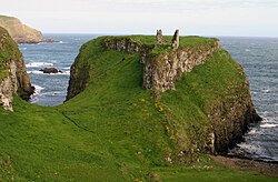
Dunseverick
Appearance
Dunseverick (alias Feigh)
| |
|---|---|
| Irish transcription(s) | |
| • Derivation: | Dún Sobhairce |
| • Meaning: | Sobhairce's fort |
 Dunseverick Castle | |
| Coordinates: 55°14′10″N 6°27′22″W / 55.236°N 6.456°W | |
| Sovereign state | United Kingdom |
| Country | Northern Ireland |
| County | Antrim |
| Barony | Cary |
| Civil parish | Billy |
| First recorded | Before 1609 |
| Settlements | Dunseverick |
| Area | |
• Total | 256.01 acres (103.60 ha) |
Dunseverick (from Irish Dún Sobhairce 'Sobhairce's fort')[3] is a hamlet near the Giant's Causeway in County Antrim, Northern Ireland. The name is also the alias for the townland of Feigh.[4] It is most notable for Dunseverick Castle.
One of the five great highways, or slighe of ancient Ireland, Slige Midluachra, had its terminal point at Dunseverick,[5] running from here to Emain Macha and further to royal Tara and the fording point on the Liffey at what is now Dublin.
The hamlet of Dunseverick itself lies in the adjacent townland of Currysheskin.[4]
References
[edit]- ^ Logainm - Placenames Database of Ireland
- ^ Northern Ireland Environment Agency. "NIEA Map Viewer". Archived from the original on 24 November 2011. Retrieved 27 July 2012.
- ^ Placenames Database of Ireland
- ^ a b Place Names NI[permanent dead link] - Dunseverick (use Map Search for location)
- ^ "An Analysis of Pre-Christian Ireland Using Mythology and A GIS". Retrieved 14 June 2015.
External links
[edit]- National Trust
- Dunseverick website
- Ballycastle Free — Dunseverick Archived 17 October 2016 at the Wayback Machine
- LibraryIreland — Dunseverick
Page Template:Asbox/styles.css has no content.


